Crown Property Overview
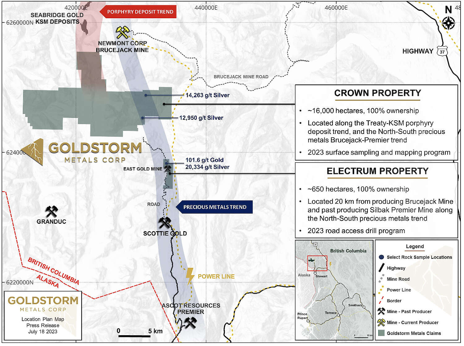
The Crown Property consists of five contiguous concessions (Orion, Fairweather, Delta, Mackie West, and High North), spanning approximately 15,819 hectares. It is situated directly south and adjacent to Seabridge Gold Inc.'s KSM Property and Newmont’s Brucejack gold mine. These claims cover the southern portion of a significant gold-copper belt, aligned with Seabridge Gold’s KSM Deposit to the north. Previous exploration within the Crown Project area has targeted high-grade precious metal veins, VMS/subaqueous hotspring mineralization, and porphyry-style gold-copper mineralization, similar to deposits found on neighboring properties. Primary exploration has occurred in four key areas (Orion, Fairweather, Delta, and Electrum Occurrences), where high-grade precious metal veins, VMS/subaqueous hotspring mineralization, and porphyry-style gold-copper mineralization have been identified. Extensive parts of this large property remain under-explored, as historical work has focused mainly on these four areas. Recent geological reconnaissance and rock sampling, especially around the retreating glacial ice sheets, have revealed newly exposed mineralization.
|
Crown Property Location |
Crown Property Concession |
2024 Work Program
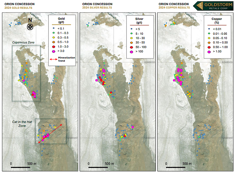
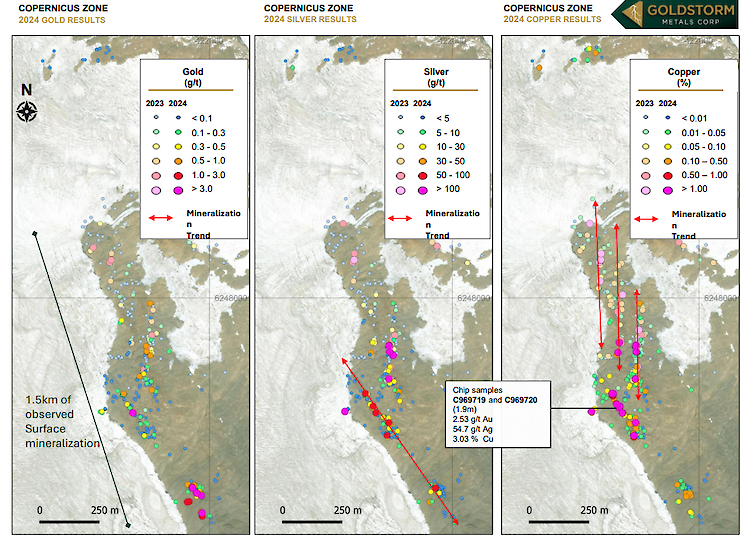
At the Crown Property, extensive mapping and sampling programs were undertaken by our crews collecting 627 samples during 2024. On the Orion Concessions crews delineated multiple stratiform mineralized trends within volcaniclastic rocks at the Copernicus Zone, located along the upper Orion Spine. Three structures trending to the north, and one trending to the northwest, have been identified over 1,500 m of length. Mineralization located over 500 m to the north suggests that the zone may extend under the Frank Mackie Glacier and is potentially a VMS style deposit associated with an anomalous magnetic high. At the Cat in the Hat Zone, also on Orion, gold-bearing veins trending northeasterly within rhyolitic rocks have been discovered, extending into previously unsampled glacial ablation zones.
Sampling highlights from the Copernicus and Cat in the Hat Zones include:
- Grab sample (C969903) returned 30.9 g/t gold and 42.39 g/t silver from the Cat in the Hat Zone
- 1.9 meter continuous chip samples (C969719 and C969720) returned 2.53 g/t gold, 54.7 g/t silver and 3.3% copper located 290 meters south of the original Copernicus showing
- meter chip sample (C970612) returned 8.76 g/t gold and 7.62 g/t silver located 650 meters south of the original Copernicus showing
- 16 samples taken within the Copernicus Zone returned greater than 1% copper, with one sample (C969842) assaying 0.58 g/t gold, 625 g/t silver, and 6.57% copper at the original Copernicus showing
- Mineralized samples were found to correlate with a magnetic high geophysical anomaly
On the Fairweather Concession, reconnaissance was conducted on three significant polymetallic mineralized zones known as Triton, Launch and Galileo. Sampling at the Triton Zone identified a 400-meter-long trend of gold-bearing veins within pyroclastic volcanic rocks. At the Launch Zone, crews found northwest- and west-trending polymetallic mineralization, characterized by pods and veins within siltstone beds, as well as crosscutting the formations. At the Galileo Zone, crews observed mineralization trending west over 800 meters, with multiple parallel polymetallic veins found within volcanic rocks and mudstones.
Sampling highlights from the Launch, Galileo, and Triton Zones include:
- Grab sample (C969905) returned 55.2 g/t g gold and 82.71 g/t silver at the Launch Zone.
- Semi-massive sulphides within siltstone were discovered 650 m north of the Launch Zone highlighted by grab sample (C969892), which returned 2.42 g/t gold, 345 g/t silver, 0.68% copper, 12.22% lead, and 27.29% zinc.
- Grab sample (C969829) taken at the Galileo Zone returned 0.29 g/t gold, 925 g/t silver, 3.38% lead, and 2.32% zinc.
- Analyses of 38 samples collected at the Triton Zone had a calculated average of 0.88 g/t gold
On the Mackie West Concession, initial sampling discovered molybdenum rich boulders and traced them to source in basalt outcrop. Mineralogy of some of the boulders indicates there may be a porphyry-type molybdenum deposit nearby associated with a buried felsic intrusion.
Sampling highlights include:
- Float samples with high molybdenum (C969920) returned 8916 ppm molybdenum
- Traced to source with grab sample (A0839824), which returned 2159 ppm molybdenum
2023 Work Program
During the 2023 exploration season Goldstorm exploration geologists undertook a substantial reconnaissance program across various Crown Concessions mostly focused on the Orion, Fairweather concessions and lesser on Delta Concessions. This work was comprised of mapping and sampling with particular emphasis placed on several newly exposed outcrops revealed by recent glacial recession.
Work completed at Orion included a total of 1,057 rock samples consisting of 7 channel saw-cut, 284 chip, and 766 grab samples. Results from this program consisted of some very promising discoveries found along a prominent north-trending silicified and gossanous ridgeline that measures 900 meters (m) wide by 6,500 m long.
Within the Orion Concessions, exploration efforts specifically targeted a new zone, known as the Copernicus, along the upper Orion Spine. The gossanous area spans a 200-m-wide by 800-m-long concentration of sulphide mineralization containing copper, silver, zinc, and cobalt. Within this zone, 229 samples were collected, including a 0.25 m chip sample (A0519298) that yielded 0.67 g/t gold, 320.0 g/t silver, 11.96 % copper, 0.088 % cobalt, and 0.55 % zinc, as well as a 0.5 m saw-cut channel sample (OR-23-01) that yielded 0.28 g/t gold, 226.0 g/t silver, 6.95 % copper, 0.079 % cobalt, and 0.37 % zinc. A continuous channel sample line, comprised of six samples (OR-23-02), averaged 0.14 g/t gold, 57.0 g/t silver, 1.71 % copper, 0.015 % cobalt, and 0.15 % zinc over 5.15 m.
Work on the Fairweather and Delta Concessions in 2023 at Fairweather and Delta focused on prospecting newly exposed outcrops due to recent glacial ablation and building upon the historical discoveries made on the Property. Reconnaissance sampling was conducted on both concessions totaled 720 rock samples (620 at Fairweather and 100 at Delta) which were collected as 203 chip samples and 517 grab samples. Highlights include grab samples taken at Fairweather which returned 1.18 g/t gold, 2,656 g/t silver, 0.55 % copper, 7.65 % lead, and 5.03 % zinc and 11.30 g/t gold, 89.02 g/t silver, 0.82 % copper and 1.37 % zinc from narrow steeply dipping structures that may be associated to large bulk-tonnage, intrusive-related systems.
Reconnaissance of recently exposed fresh outcrop on the eastern area of the Fairweather Concession has led to the discovery of three significant polymetallic mineralized zones referred to as the Galileo, Triton and Launch zones. These zones were observed to contain precious metals hosted in structurally associated veining and semi-massive sulphide pods and were found in close proximity to the Triassic-Jurassic contact commonly known as the Kyba Red line. This fault contact, between Triassic Stuhini and Jurassic Hazelton units, trends northerly through both the Fairweather and Delta concessions forming a previously unmapped “Red Line” which may represent a low-angled thrust fault which occurs commonly throughout the region.
The Launch Zone, located near the upper Fairweather Glacier, occurs as fracture-controlled mineralization along well-defined shear zones and pods of semi-massive sulphide mineralization within a siltstone-mudstone host, close to the contact area with the Texas Creek intrusives. Representative chip sampling within this area returned 1.95 g/t gold, 15.09 g/t silver, 0.12 % copper over 3.0 meters (m) and 4.6 g/t gold, 118.5 g/t silver, 0.83 % copper over 2.0 m. This mineralization may be associated with transform structures related to thrust faulting juxtaposing upper Hazelton rocks with Stuhini rocks.
The Galileo Zone was discovered by reconnaissance mapping and sampling crews working along the southern portion of the Fairweather claim along freshly exposed outcrop, adjacent to the Frank Mackie glacier. This polymetallic, silver-rich sulphide veins-veinlets system with conjugate gold-rich quartz pyrite veins/veinlets occur within volcaniclastic rocks is believed to be from the Hazelton Formation. This zone can be traced approximately 500 east-west by 200 m north-south and remains open in all directions. Galileo is considered a priority target for future exploration.
The Triton Zone, also located on the Fairweather Concession along the north boundary area, was discovered as a northwest-trending belt of recently exposed volcanic rocks with gold-silver mineralized shear-host veins and veinlets trending along an east-west structural corridor. The highest grab sample assayed 8.3 g/t gold and 48.8 g/t silver.
Historical Exploration Work
Earlier exploration programs within the Crown Project area have focused on discovery of high-grade precious metal veins, VMS/ subaqueous hot-spring mineralization, or porphyry-style gold-copper mineralization, similar to some of the deposits found on nearby properties. Work has been undertaken primarily in four areas of the Property (Orion, Fairweather, Delta and Electrum Occurrences) where high-grade precious metal veins, VMS/ subaqueous hot-spring mineralization and porphyry-style gold- copper mineralization has been revealed. Historical work has primarily been concentrated in the four previously mentioned areas, leaving extensive regions of this large property under-explored. More recent geological reconnaissance and rock sampling have been concentrated in areas near the edges of retreating glacial ice sheets and have successfully discovered freshly exposed mineralization.
Geology
In the central part of the Property the southern extent of the McTagg Anticlinorium has been mapped, with a core of Stuhini Group rocks exposed along a north-south nunatak that emerges from a broad glacial field. MT geophysical surveying has suggested that the anticlinal limbs are steeply dipping, but there is also geophysical data that suggests that the eastern contact of Stuhini Group rocks may be thrust over Hazelton Group along the possible southern extension of the Sulphurets Thrust Fault. This contact zone is a prospective area to search for mineralization
The eastern part of the Property is underlain by Hazelton Group units that appear to be folded into a north-northwest trending synform with a core of sedimentary rocks comprised of mudstone, siltstone, shale and fine clastic rocks that host many of the mineral occurrences in the area. Past exploration in the Delta and Fairweather areas has been focused on argillite-hosted Ag-Au-Pb-Zn mineralization that may be volcanogenic in origin. The sedimentary unit is underlain by a thin unit of calc-alkaline volcanic rocks. These volcanic rocks in the area of the Feld occurrence are described as a 75 to 150 meter-wide band of felsic pyroclastics that may belong to the Mount Dilworth Formation. This unit is underlain by a thicker sequence of volcaniclastic rocks that are likely part of the Betty Creek Formation. No intrusions have been mapped in the central and eastern parts of the Property, however, due to the extensive ice coverage they could be hidden from view or may be present at depth. Some historical assessment reports mention feldspar porphyry dikes and small stocks, which support the possibility of buried intrusions.
Images:
Orion Concessions – 2024 Sample Results for Gold, Silver and Copper
Orion Concessions – COPERNICUS ZONE - 2024 Sample Results for Gold, Silver and Copper


