Property Highlights
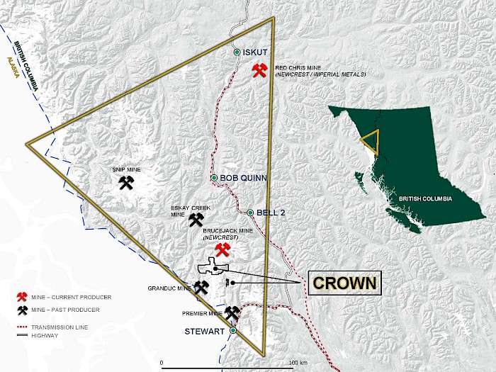
- Large land package of 16,469 hectares in the Golden Triangle of British Columbia;
- Approximately 45 kilometers north-northwest of the community of Stewart with gravel road access to the southeastern concessions;
- On trend and bordering Seabridge Gold Inc.’s KSM Property that hosts several large, porphyry gold copper deposits to the north;
- Close to nearby (current and former) producing mines:
- 4 km southwest of Newmont Corp's Brucejack Mine which has produced 2.0 million ounces of gold since 2017, with Proven plus Probable reserves (Dec. 2023) of 11.5 M tonnes at 8.44 g/t gold and 34.7 g/t silver containing 3.1 million ounces of gold and 12.8 million ounces of silver;
- 4 km to the north of the Scottie Gold Deposit where mining from 1981 to 1985 mining totalled 160,264 tonnes at an average grade of 16.2 g/t gold, recovering 95,000 ounces of gold and 52,200 ounces of silver;
- 14 km north of the Granduc Mine which from 1971 to 1985, produced approximately 190,000 tonnes of copper, 4 million ounces of silver and 64,000 ounces of gold, at average grades of 1.23% copper, 0.13 g/t gold and 8.0 g/t silver).
- The presence of geochemically anomalous rock samples containing precious metal-bearing stockwork veins and exhalative-type silica-pyrite bands suggest the possibility of significant mineralization in at least five areas of the Crown Property;
- Click here to view the 2022 Technical Report on the Crown Project.
Overview
The 16,468 hectare Crown Property is located 45 minutes from the town of Stewart BC, and situated in the Golden Triangle of British Columbia. Portions of the Property is accessible by gravel roads to the southeastern concessions. The Crown claims cover the southern portion of a signification gold copper belt and is on trend with Seabridge Gold’s KSM Deposit to the north. Earlier exploration programs within the Crown Project area have focused on discovery of high-grade precious metal veins, VMS/ subaqueous hotspring mineralization, or porphyry-style gold-copper mineralization, similar to some of the deposits found on nearby properties. Work has been undertaken primarily in four areas of the Property (Orion, Fairweather, Delta and Electrum Occurrences) where high-grade precious metal veins, VMS/ subaqueous hotspring mineralization and porphyry-style gold- copper mineralization has been revealed. Historical work has primarily been concentrated in the four previously mentioned areas, leaving extensive regions of this large property under-explored. Recent geological reconnaissance and rock sampling have also been concentrated in areas near the edges of retreating glacial ice sheets and have successfully discovered freshly exposed mineralization.
Location Map
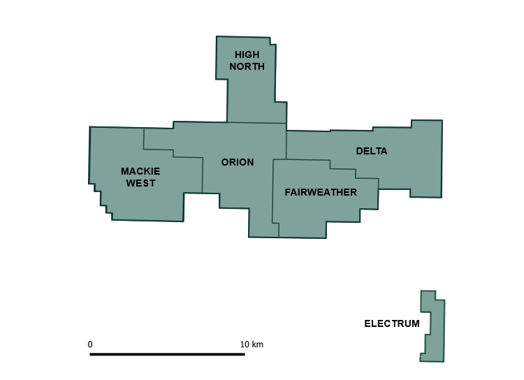
Orion Occurrence
In the central part of the Crown claim block, the Orion showing consists of a stockwork zone of quartz-pyrite-arsenopyrite veinlets and sulphide fracture fillings. Veinlets are generally 1 to 10 centimetres wide with coarse pyrite and patchy arsenopyrite. The arsenopyrite typically comprises 2% to 4 %, and locally up to 20%, of the narrow sulfide stringers. Host rocks are felsic volcanics and carbonaceous sedimentary rocks, underlain by andesitic agglomerate and tuff, with nearby small syenite stocks. The largest, most intensely fractured zone is at least 15 metres wide within the more extensive stockwork area that is exposed over a length of about 40 m. Trenching of the stockwork zone in 1994 returned 2.54 g/t gold, 1.36 % Arsenic across 13 m of brecciated rhyolite.
The Tribe showing, located 1 km north of Orion, is within a sequence of chert, andesite agglomerate and tuff intruded by small syenite stocks. Areas of strong sericitic alteration contain quartz-carbonate veins and stockworks that locally carry pyrite, pyrrhotite, arsenopyrite, sphalerite, and galena. The best gold assay was from samples of a 13 by 30 metre stockwork zone, reported as 12.5 g/t gold and 3.1 g/t silver over 0.4 m.
Fairweather Occurrence
The Fairweather Zone, in the southeastern part of the claim block, is underlain by dacitic to andesitic volcanics and fine-grained sedimentary rocks intruded by feldspar porphyry bodies. Trenches have exposed mineralization consisting of quartz-calcite veins with galena, sphalerite, tetrahedrite, chalcopyrite, and pyrite carrying gold and significant amounts of silver. En echelon veins, up to 60 cm wide, occur within northeast-trending shears surrounded by zones of ankerite alteration. A pyritized structure between 5 and 15 metres in width, with a 125 m strike length was sampled, yielding a weighted average of 4.04 g/t gold over a 7.15 m width. A 2.0 m trench channel sample from a tetrahedrite-rich shear returned over 2000 g/t silver.
Delta Occurrence
In the eastern part of the project area, the Delta occurrence and other nearby showings are hosted by Middle Jurassic siltstone and intermediate volcaniclastics, with nearby small Eocene feldspar porphyry intrusions. Broad zones of strongly gossanous ankerite-sericite alteration contain cm-scale quartz-sulphide veins, up to 10 cm wide and dipping generally to the northwest, that have returned up to 13.7 g/t gold with significant silver, copper, lead, stibnite and zinc values.
Historic soil sampling has defined an extensive area, about 500 m in diameter, of anomalous gold, Arsenic, Lead, Sb and Zn at the Delta Northeast zone. The source of this large anomaly has yet to be defined, but the geological environment is favourable for Eskay Creek-style mineralization, similar to fine-grained stratiform lead, zinc, silver-rich mineralization found in siltstone at the 4-J showing, located about 4 km south of the project.
Electrum Occurrence
The Electrum property covers approximately 650 hectares and is located directly between the past producing Silbak Premier mine some 25 Km south and Pretium Resource’s Valley of the Kings deposit (production commenced in 2017) some 20 Km to the north. A well-developed 40 km road directly links the property to the bulk tonnage shipping terminals in Stewart. Electrical power lines come within 18 km of the property and can be continued along the existing haul road. The past producing Big Missouri mine is also located 14 km down the haul road from the Electrum Property.
Mineralization on the Electrum property is controlled by two major fault lines that locally host bonanza type gold grades along with broader stockworked zones within a complex geological model. Like the nearby Valley of the Kings deposit, gold and silver mineralization occurs as coarse electrum in several generations of quartz-carbonate veins and vein breccias hosted within a deformed island arc-related sequence. The intermediate to low sulphidation mineralization is present in most of the veins with pyrite, sphalerite, galena and chalcopyrite. Precious metal mineralization has been traced on surface over lengths of several tens of meters to over a hundred meters, pinching and swelling along strike. Drilling has encountered gold-silver mineralization at depths greater than 200 metres from surface. The Electrum property hosts the historic East Gold Mine where intermittent small-scale production between 1939 and 1965 produced 3,816 oz of gold and 2,442 oz of silver from 45 tons of hand selected ore (BC Minsitry of Mines Assessment Report 30206a).
Between 2006 and 2007 a total of 66 diamond drill holes comprising 15,369 meters was completed (American Creek Resources Ltd. Press Release June 6, 2007, December 11, 2007 and March 16, 2008, BC Ministry of Mines Assessment Report 30206a). Multiple targets were tested and significant values have been returned, such as 31.40 g/t gold and 19.0 g/t silver over 2.0 meters and 440.8 g/t gold and 400.0 g/t silver over 0.52 meters.
Of the four main targets, the Electrum area in the southeast part of the Property has received the greatest amount of drilling to date. This work has primarily tested for extensions of epithermal vein systems that have returned several high silver and gold values from limited underground mining and trench exposures. Several holes intersected relatively wide zones containing variable quartz-sulfide veining that returned moderate precious metal values. These intercepts are located beneath surface exposures that were subsequently blasted, trenched and bulk sampled in the New Blast Zone. The 3.8 tonne bulk sample collected from this 5-m-wide zone averaged 2.82 g/t gold, 539 g/t silver, 1.96% lead and 1.97% zinc. Localized veins, found within some of the wider drill intervals, contain electrum and silver sulfosalt minerals that have returned significant silver and gold values over narrow widths.